Tide Apps for iPhone and Android - Fishing Tides

Tidal Apps for Fishing & Inshore Boating

  • Home
  • FREE Decal
  • Tides for Android
  • Tides for iPhone
  • Florida Tides
  • Tides by Region
  • Contact

Connecticut Tide Chart

by Skiff Life Join Discussion

App Icon
View in iTunes
$4.99

Connecticut Tide Chart

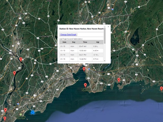
Accurate, simple to use Satellite Map based Connecticut tide charts of the all NOAA based Connecticut tide stations on a simple to use satellite map. Designed by Connecticut fishermen and Professional Connecticut Fishing Guides.

NO SPAM ADS, SIMPLE TO USE...100% AD FREE.

Other Features:

Ability to forecast Connecticut tides from NOAA by setting date and period for any of the tidal stations for the entire State of Connecticut tide tables.

Excellent support for any issues, questions or new features...simply email: [email protected] and we'll show you how Apple support is meant to be.

Auto-save last location for easy reference to your last tide station the next time you use the tide app.

Included is the ability to zoom and view satellite imagery for fishing ground characteristics to compare with tide movement.

Advanced tide graphs allow for you to judge the level of water movement for optimal fishing between high and low tide in Connecticut between tide stations so you can follow the tide flow for the entire day.

Recent Feedback:
"NesTides ability to display tide predictions and actual tidal flow graphs allow me to extend fishing trips by following different tide station tide charts and moving with the tide flow. The satellite view allows me to explore and discover new fishing grounds I never knew existed. Absolutely the best fishing software tool I have ever used. ," said USCG Captain Mike K.

Connecticut Tide Chart stations include (partial list see website for full list):

WEST MYSTIC, MYSTIC RIVER,Silver Eel Pond, Fishers Island, N.Y.,NEW LONDON, State Pier,Yale boathouse,Norwich,Niantic, Niantic River,Saybrook Jetty,Saybrook Point,Lyme, highway bridge,Essex,Hadlyme,Tylerville,Haddam,Higganum Creek,Maromas,Middletown,Rocky Hill,South Hartford,Hartford,Westbrook, Duck Island Roads,Clinton Harbor,Madison,Guilford Harbor,Sachem Head,Branford, Branford River,Lighthouse Point, New Haven Harbor,New Haven Harbor, New Haven Reach,Gulf Beach,Milford Harbor,Sniffens Point,Stratford, I-95 bridge,Long Hill,Shelton,BRIDGEPORT,Black Rock Harbor,Southport, Southport Harbor,SAUGATUCK, SAUGATUCK RIVER,South Norwalk,Rowayton, Fivemile River,Long Neck Point,Stamford,Cos Cob Harbor
  • App Screenshot
  • App Screenshot
  • App Screenshot
  • App Screenshot

Filed Under: Tide Chart Apps Tagged With: Connecticut tide, high tide today, high-tide, low tide, low tide today, saltwater tides, tide chart, tide tables, tide times, tides, tides for fishing, tides near me, what time is high tide, when is low tide

Chesapeake – Tidewater Tides

by Skiff Life Join Discussion

App Icon
View in iTunes
$6.99

Chesapeake - Tidewater Tides

Accurate, simple to use Satellite Map based tide charts of the entire Chesapeake and Tidewater marine tidal stations on a simple to use satellite map. Designed by fishermen and fishing guides.

NO SPAM ADS, SIMPLE TO USE...100% AD FREE.

This edition covers the following state's tide charts: Virginia tides, Maryland tides, and Washington D.C. (District of Columbia) tides.

Other Features:

Easy to Use, advanced tide graphs allow for you to judge the level of water movement for optimal fishing between high and low tide.

Ability to forecast tides from NOAA by setting date and period for any of the tidal stations for the entire West Coast of the U.S.: Virginia, Maryland, and Washington D.C.

When GPS is available we auto-locate your position and zoom to the map for surrounding NOAA tide stations near you.

Included is the ability to zoom and view satellite imagery for fishing ground characteristics to compare with tide movement.

  • App Screenshot

Filed Under: Tide Chart Apps Tagged With: high tide today, high-tide, low tide, Maryland tides, saltwater tides, tide chart, tide tables, tides, tides for fishing, Virginia tides, Washington D.C. tides - District of Columbia tides

California Tides & Weather

by Skiff Life Join Discussion

App Icon
View in iTunes
$4.99

California Tides & Weather

Accurate, simple to use Satellite Map based California tide charts of the all NOAA based California tide stations on a simple to use satellite map. Designed by California fishermen and Professional California Fishing Guides.

NO SPAM ADS, SIMPLE TO USE...100% AD FREE.

Other Features:

Ability to forecast California tides from NOAA by setting date and period for any of the tidal stations for the entire State of Florida tide tables.

Excellent support for any issues, questions or new features...simply email: [email protected] and we'll show you how Apple support is meant to be.

When GPS is available auto-locate your position and zoom to the map for surrounding NOAA California tide charts.

Included is the ability to zoom and view satellite imagery for fishing ground characteristics to compare with tide movement.

Advanced tide graphs allow for you to judge the level of water movement for optimal fishing between high and low tide in Florida between tide stations so you can follow the tide flow for the entire day.

Recent Feedback:
"NesTides ability to display tide predictions and actual tidal flow graphs allow me to extend fishing trips by following different tide station tide charts and moving with the tide flow. The satellite view allows me to explore and discover new fishing grounds I never knew existed. Absolutely the best fishing software tool I have ever used. ," said USCG Captain Mike K.

California tide tables, California tides, California tide charts

NOAA Tides Stations Include:
Baja California tides
San Carlos tides
Isla Guadalupe tides
Ensenada, Todos Santos Bay tides
Southern California tides
Imperial Beach tides
Point Loma tides
SAN DIEGO (Broadway) tides
National City, San Diego Bay tides
Quivira Basin, Mission Bay tides
Crown Point, Mission Bay tides
La Jolla (Scripps Institution Wharf) tides
San Clemente tides
San Pedro Channel tides
Newport Bay Entrance, Corona del Mar tides
Balboa Pier, Newport Beach tides
Santa Ana River entrance (inside) tides
Los Patos (highway bridge) tides
Long Beach
Cabrillo Beach tides
LOS ANGELES (Outer Harbor) tides
El Segundo, Santa Monica Bay tides
Santa Monica, Municipal Pier tides
Port Hueneme tides
Ventura tides
Rincon Island, Mussel Shoals tides
Santa Barbara tides
Santa Barbara Islands tides
Wilson Cove, San Clemente Island tides
Catalina Harbor, Santa Catalina Island tides
Avalon, Santa Catalina Island tides
Santa Barbara Island tides
San Nicolas Island tides
Prisoners Harbor, Santa Cruz Island tides
Bechers Bay, Santa Rosa Island tides
Cuyler Harbor, San Miguel Island tides
Outer Coast, Port San Luis tides
Point Arguello tides
PORT SAN LUIS tides
San Simeon tides
Mansfield Cone tides
Carmel Cove, Carmel Bay tides
Monterey Bay tides
MONTEREY, MONTEREY BAY tides
General Fish Company Pier tides
Moss Landing, Ocean Pier tides
Pacific Mariculture Dock tides
Elkhorn, Elkhorn Slough tides
Kirby Park, Elkhorn Slough tides
Elkhorn Slough railroad bridge tides
Santa Cruz, Monterey Bay tides
Ano Nuevo Island tides
Pillar Point Harbor, Half Moon Bay tides
Southeast Farallon Island tides
San Francisco Bar tides
Corte Madera Creek tides
Point San Quentin tides
Carquinez Strait tides
Mare Island tides
Vallejo, Mare Island Strait tides
Edgerley Island, Napa River tides
Brazos Drawbridge, Napa River tides
Napa, Napa River tides
Selby tides
Crockett tides
Benicia tides
Martinez-Amorco Pier tides
Suisun Bay tides
Suisun Slough entrance tides
Pierce Harbor, Goodyear Slough tides
Joice Island, Suisun Slough tides
Montezuma Slough Bridge tides
Bradmoor Island, Nurse Slough tides
Meins Landing, Montezuma Slough tides
Montezuma Slough tides
Point Buckler tides
Mallard Island Ferry Wharf tides
Pittsburg, New York Slough tides
San Joaquin River tides
Antioch tides
Threemile Slough entrance tides
Prisoners Point tides
Eureka tides
Eureka Slough Bridge tides
Samoa tides
Arcata Wharf tides
Mad River Slough, Arcata Bay tides
Trinidad Harbor tides
CRESCENT CITY tides
Pyramid Point, Smith River tides

  • App Screenshot
  • App Screenshot

Filed Under: Tide Chart Apps Tagged With: california tide chart, california tide times, California Tides, high tide today, high-tide, low tide, noaa tides, saltwater tides, tide chart, tide tables, tides, tides for fishing

Alabama Tide Chart & Weather

by Skiff Life 2 Comments

App Icon
View in iTunes
$4.99

Alabama Tide Chart & Weather

Accurate, simple to use Satellite Map based Alabama tide charts of the all NOAA based Alabama tide stations on a simple to use satellite map. Designed by Alabama fishermen and Professional Alabama Fishing Guides.

NO SPAM ADS, SIMPLE TO USE...100% AD FREE.

Other Features:

Ability to forecast Alabama tides from NOAA by setting date and period for any of the tidal stations for the entire State of Alabama tide tables.

Excellent support for any issues, questions or new features...simply email: [email protected] and we'll show you how Apple support is meant to be.

Auto-save last location for easy reference to your last tide station the next time you use the tide app.

Included is the ability to zoom and view satellite imagery for fishing ground characteristics to compare with tide movement.

Advanced tide graphs allow for you to judge the level of water movement for optimal fishing between high and low tide in Alabama between tide stations so you can follow the tide flow for the entire day.

Recent Feedback:
"NesTides ability to display tide predictions and actual tidal flow graphs allow me to extend fishing trips by following different tide station tide charts and moving with the tide flow. The satellite view allows me to explore and discover new fishing grounds I never knew existed. Absolutely the best fishing software tool I have ever used. ," said USCG Captain Mike K.

Alabama Tide Chart stations include (partial list see website for full list):

Alabama Point,Mobile Point (Fort Morgan),Gulf Shores, ICWW,Bon Secour, Bon Secour River,DAUPHIN ISLAND,East Fowl River, Hwy 193 Bridge,West Fowl River, Hwy 188 bridge,Point Clear, Mobile Bay,Dog River Bridge,Coast Guard Sector Mobile,Meaher State Park, Mobile Bay,MOBILE, Mobile River (State Dock),William Brooks Park, Chichasaw Creek,Lower Hall Landing, Tensaw River,Bayou La Batre, Mississippi Sound,Bayou LaBatre Bridge,Grand Bay NERR, Mississippi Sound,Point of Pines, Bayou Cumbest,Hollingsworth Point, Davis Bayou,Petit Bois Island, Mississippi Sound,Ship Island, Mississippi Sound,Horn Island, Mississippi Sound,Dock E, Port of Pascagoula,Pascagoula, Mississippi Sound,Graveline Bayou Entrance,Gulfport Harbor, Mississippi Sound,Biloxi (Cadet Point), Biloxi Bay,Turkey Creek, Bernard Bayou,Handsboro Bridge, Bernard Bayou,Cat Island,Pass Christian Yacht Club, Mississippi Sound,Wolf River, Henderson Avenue bridge,St. Louis Bay entrance,Waveland,Pearlington, Pearl River

  • App Screenshot
  • App Screenshot
  • App Screenshot
  • App Screenshot

Filed Under: Tide Chart Apps Tagged With: high tide today, high-tide, low tide, orange beach tide chart, saltwater tides, tide chart, tide schedule, tide tables, tides, tides for fishing

Alaska Tide Tables

by Skiff Life Start Discussion

App Icon
View in iTunes
$4.99

Alaska Tide Tables

Easy to use tide charts displayed on a Satellite Map for all of Alaska and parts of British Columbia on a simple to use satellite map. Designed by fishermen and fishing guides.

NO SPAM ADS, SIMPLE TO USE...100% AD FREE.

Other Features:

Ability to forecast tides from NOAA by setting date and period for any of the tidal stations for the entire State of Alaska tide tables.

When GPS is available we auto-locate your position and zoom to the map for surrounding NOAA tide stations near you.

Included is the ability to zoom and view satellite imagery for boating and fishing ground characteristics to compare with tide movement.

Support URL: https://www.nestides.com/contact-us/
Privacy Policy & Terms of Use URL: http://www.progresstechnologies.com/blog/120/privacy-policy-and-terms-of-use/

  • App Screenshot

Filed Under: Tide Chart Apps Tagged With: alaska tide charts, Alaska tide tables, alaska tides, high tide today, high-tide, low tide, saltwater tides, tide chart, tide charts, tide tables, tides, tides for fishing

Tide Chart & Weather

by Skiff Life Join Discussion

App Icon
View in iTunes
$4.99

Alabama Tide Chart & Weather

Accurate, simple to use Satellite Map based Alabama tide charts of the all NOAA based Alabama tide stations on a simple to use satellite map. Designed by Alabama fishermen and Professional Alabama Fishing Guides.

NO SPAM ADS, SIMPLE TO USE...100% AD FREE.

Other Features:

Ability to forecast Alabama tides from NOAA by setting date and period for any of the tidal stations for the entire State of Alabama tide tables.

Excellent support for any issues, questions or new features...simply email: [email protected] and we'll show you how Apple support is meant to be.

Auto-save last location for easy reference to your last tide station the next time you use the tide app.

Included is the ability to zoom and view satellite imagery for fishing ground characteristics to compare with tide movement.

Advanced tide graphs allow for you to judge the level of water movement for optimal fishing between high and low tide in Alabama between tide stations so you can follow the tide flow for the entire day.

Recent Feedback:
"NesTides ability to display tide predictions and actual tidal flow graphs allow me to extend fishing trips by following different tide station tide charts and moving with the tide flow. The satellite view allows me to explore and discover new fishing grounds I never knew existed. Absolutely the best fishing software tool I have ever used. ," said USCG Captain Mike K.

Alabama Tide Chart stations include (partial list see website for full list):

Alabama Point,Mobile Point (Fort Morgan),Gulf Shores, ICWW,Bon Secour, Bon Secour River,DAUPHIN ISLAND,East Fowl River, Hwy 193 Bridge,West Fowl River, Hwy 188 bridge,Point Clear, Mobile Bay,Dog River Bridge,Coast Guard Sector Mobile,Meaher State Park, Mobile Bay,MOBILE, Mobile River (State Dock),William Brooks Park, Chichasaw Creek,Lower Hall Landing, Tensaw River,Bayou La Batre, Mississippi Sound,Bayou LaBatre Bridge,Grand Bay NERR, Mississippi Sound,Point of Pines, Bayou Cumbest,Hollingsworth Point, Davis Bayou,Petit Bois Island, Mississippi Sound,Ship Island, Mississippi Sound,Horn Island, Mississippi Sound,Dock E, Port of Pascagoula,Pascagoula, Mississippi Sound,Graveline Bayou Entrance,Gulfport Harbor, Mississippi Sound,Biloxi (Cadet Point), Biloxi Bay,Turkey Creek, Bernard Bayou,Handsboro Bridge, Bernard Bayou,Cat Island,Pass Christian Yacht Club, Mississippi Sound,Wolf River, Henderson Avenue bridge,St. Louis Bay entrance,Waveland,Pearlington, Pearl River

  • App Screenshot
  • App Screenshot
  • App Screenshot
  • App Screenshot

Filed Under: Tide Chart Apps Tagged With: high tide today, high-tide, low tide, saltwater tides, tide chart, tide tables, tides, tides for fishing

What is Living the Skiff Life?

by fishing

Tides and Living the Skiff Life come hand in hand.  Knowing the tides in your location can make or break your boating experience for that day.  Knowing the tides allows safe passage in tight channels while also timing fishing trips to locate when maximum water is moving as that is when fish are feeding.  Yes, fishing on outgoing or incoming tides vastly increases your chance of fishing!

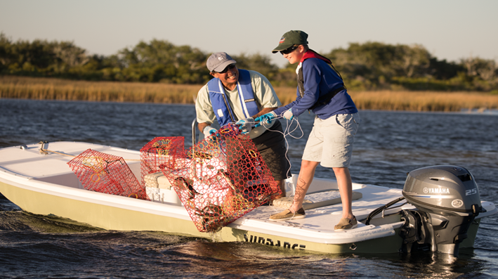
Skiff Life has just released Volume 1 of an inshore fishing guide that provides valuable insight into choosing a fishing boat.  The article is called Living the Skiff Life Volume 1. This fishing guide covers basic Carolina Skiff style flat bottom boats like the Sundance as well as more user specific flats boats like the technical poling skiff by Skimmer skiffs.  Inshore fishing can range from ankle deep water to nearshore fishing in 30-60 foot depths depending on your location so it’s important to pay close attention to the fishing & boating you plan on doing and then choosing a fishing boat to match as best you can.  You are not going to want to take out a Carolina Skiff type flat bottom boat out in 60 Feet of water in a weather advisory for example.  Pictured here is a Sundance Carolina Skiff style boat with a flat bottom:

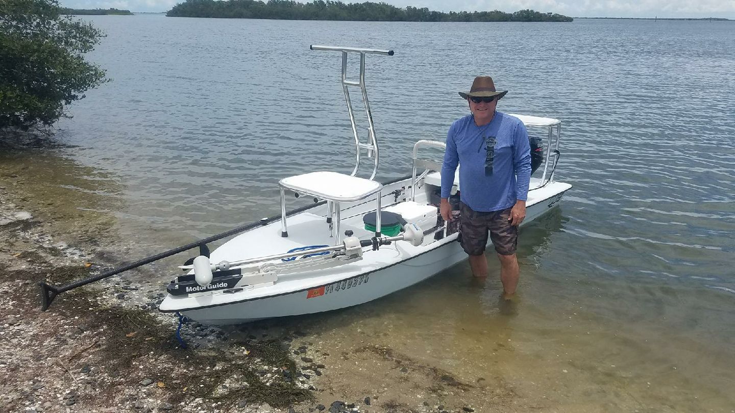
Skiff Life said their new Living The Skiff Life column will be a regular article series with goals to cover all manner of boats and their use to help educate fans in choosing a boat for sale.  Skiff Life plans to use real world experience from fishing guides and fans of their social media sites like Skiff Life Twitter and the popular Google Plus Skiff Life account.  Skiff Life features contacts and fans from all parts of the U.S.A. so they said they will focus on specific regions and fishing styles to help everyone.  For example, those Living The Skiff Life in Alaska will run an aluminum style boat with an Outboard Jet Drive due to their running rocky rivers that no prop could ever stand up to.  That same would be disastrous in South Florida where the seagrass would quickly clog the jet drive.  If a person is more inclined to enjoy many people on their boat or an occasional trip offshore, the technical poling skiff may not be the best choice in that it’s meant to silently stalk fish in shallow water and can comfortably handle 2 people like you see in the photo below.

The secret to choosing a boat is that no boat does EVERYTHING well.  Luckily, there are a tremendous amount of boat manufacturers to choose from.  Skiff Life’s Living The Skiff Life series of articles aim to help navigate those waters to help decide what boat is right for you by weighing the pros and cons of every boat by analyzing their features and how to best use them.  Once thing we know for certain is that when you stay inshore and nearshore the cost of gas decreases tremendously and the ability to experience the ocean’s bottom and all the wonder it has to offer.  Here is a link to Skiff Life’s

Living the Skiff Life

feature.

Filed Under: Slider Tagged With: flood tide, high-tide, living the skiff life, skiff life, skifflife, tides

Storm Surge tracking with NesTides NOAA Tides Editions

by fishing Start Discussion

Hurricane Isaac and Tides

Tracking Tides with Storm Surge

One of the most damaging aspects of a Hurricane is the effects storm surge can have in relation to an area’s tides.  Using a tool like Nestides Gulf of Mexico Tides Edition or Florida Tide Tables by NOAA can help you gauge how high a tide is scheduled to be in your area and then factor the time the storm will begin affecting your area.  One thing is for sure, you have an especially high tide during a tropical storm or hurricane when it hits, you can rest assured storm surge is following.  In some cases even a low tide can be equally devastating depending on how the wind blows (literally).  What is more dangerous about storm surge is that it can be delayed and catch people when their guard is down.  One thing is for is that you MUST be prepared and usually have some degree of notice as to when the storm will reach your area.  With the help of Tides software to show normal predictions you can be that much more prepared.

Purchase Tide Tables for your area here:


Here is a Storm Surge Probabilities chart from NOAA: http://www.nhc.noaa.gov/refresh/graphics_at4+shtml/092352.shtml?gm_psurge#contents

Filed Under: tide tables Tagged With: florida tides, gulf of mexico, hurricane, hurricane isaac, tide tables, tides, tropical storm

  • « Previous Page
  • 1
  • 2
  • 3
  • 4

Choose Your Device:

android app iphone app

RSS Fishing News

Tides For Fishing

Tides for Fishing

© 2023 · Skiff Life. All Rights Reserved. Third party names and products are for reference purposes only, all rights are reserved by these respective parties.