Tide Apps for iPhone and Android - Fishing Tides

Tidal Apps for Fishing & Inshore Boating

  • Home
  • FREE Decal
  • Tides for Android
  • Tides for iPhone
  • Florida Tides
  • Tides by Region
  • Contact

Florida Boat Ramps & Tides

by Skiff Life Join Discussion

App Icon
View in iTunes
$6.99

Florida Boat Ramps & Tides

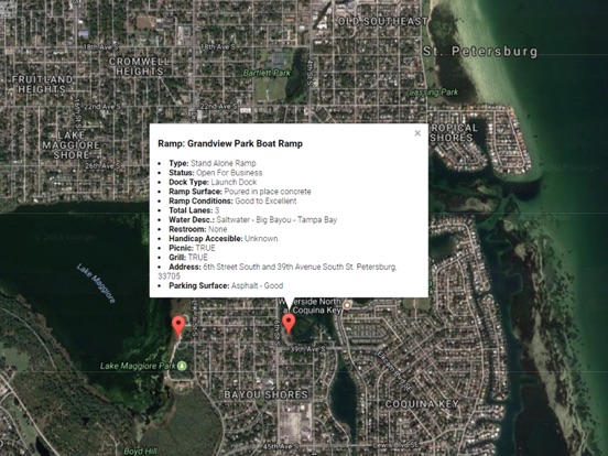
Accurate, simple to use Satellite Map based Florida Boat Ramps of all FWC public boat ramps. Designed by Florida Tournament fishermen and Professional Florda Fishing Guides. Find a functional boat ramp and discover good fishing grounds with the Satellite Map all from one app.

Satellite Map based Florida tide charts of the all NOAA based Florida tide stations on a simple to use satellite map WITH WEATHER!

NO SPAM ADS, SIMPLE TO USE...100% NO SPAM ADS.

Features the most complete information about any Boat Ramp including:
Dock Type
Ramp Surface
Ramp Conditions
Waterway Type (Freshwater or Salt)
Waterway Name
Total Lanes
Dock Type
Parking Lot Surface
Parking Lot Condition
Trailer
Restroom
Handicap Access
Picnic
Lighting
Grill
Street, City, County, Zip

Other Features:

Ability to forecast Florida tides from NOAA by setting date and period for any of the tidal stations for the entire State of Florida tide tables.

Included is the ability to zoom and view satellite imagery for fishing ground characteristics to compare with tide movement.


Advanced tide graphs allow for you to judge the level of water movement for optimal fishing between high and low tide in Florida between tide stations so you can follow the tide flow for the entire day.

Auto saves your map location so you can return quickly the next time you use the boat ramp app.

Excellent support for any issues, questions or new features...simply email: [email protected] and we'll show you how Apple support is meant to be.

Included is the ability to zoom and view satellite imagery for fishing ground characteristics to compare with tide movement.

Recent Feedback:
"The ability to display real-time status of boat ramps allows me to extend fishing trips by choosing a boat ramp that is safe & fully functional. The satellite view allows me to explore and discover new fishing grounds I never knew existed near those boat ramps. Absolutely the best fishing software tool I have ever used. ," said USCG Captain Mike K.
  • App Screenshot
  • App Screenshot
  • App Screenshot
  • App Screenshot

Filed Under: Tide Chart Apps Tagged With: best saltwater fishing times, California Tides, fishing forecast, florida boat ramps, high tide chart, high tide today, high-tide, low tide, low tide today, noaa tides, Oregon Tides, saltwater tides, tide chart, tide chart near me, tide charts, tide finder, tide schedule, tide tables, tides, tides and currents, tides for fishing, tides for fishing app, tides near me, tides today, Washington Tides

Florida Reefs, Weather & Regs

by Skiff Life Start Discussion

App Icon
View in iTunes
$6.99

Florida Reefs, Weather & Regs

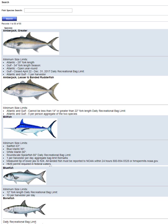
Accurate, simple to use Satellite Map based Florida Artificial Reef locations of Federal & Florida reef coordinates on a simple to use satellite map. Designed by Florida divers and fishermen and Professional Florida Fishing Guides & Diving enthusiasts. This app ALSO features our handy Florida fishing regulations & fish identification guide to guarantee you harvest within the legal limits.

NO SPAM ADS, SIMPLE TO USE...100% AD FREE. No annoying In-App purchases...pay once to help support this app and get all the features.

Critical Information to gauge value of the reef for fishing & diving:

- Latitude/Longitude
- Deployment Description (Type of Material: Boat, Culverts, etc.)
- Deployment Tonnage
- Deployment Depth
- Deployment Relief
- Jurisdiction/Coast/County
- Material Cat./Desc. (Example: Rubble/Concrete)
- Deploy Date
- Deployment Accuracy

Excellent support for any issues, questions or new features...simply email: [email protected] and we'll show you how Apple support is meant to be.

Auto-save last location for easy reference to your last reef location the next time you use the tide app.

Included is the ability to zoom and view satellite imagery.

Recent Feedback:
"The ability to display reef locations and actual reef information allow me to plan & explore near-shore & offshore fishing trips in advance The satellite view allows me to explore and discover new fishing grounds and plan multiple reef location stops in a single day based on close proximity to each reef location. Absolutely the best fishing software tool I have ever used. ," said USCG Captain Mike K.

  • App Screenshot
  • App Screenshot
  • App Screenshot
  • App Screenshot

Filed Under: Tide Chart Apps Tagged With: best saltwater fishing times, California Tides, fishing forecast, high tide chart, high tide today, high-tide, low tide, low tide today, noaa tides, Oregon Tides, saltwater tides, tide chart, tide chart near me, tide charts, tide finder, tide schedule, tide tables, tides, tides and currents, tides for fishing, tides for fishing app, tides near me, tides today, Washington Tides

Florida Beaches & Weather

by Skiff Life Join Discussion

App Icon
View in iTunes
$6.99

Florida Beaches & Weather

NO SPAM Ads, just a beautiful list of over 2,200 Florida Beaches with Weather to discover and explore all that Florida has to offer on a fantastic satellite map so that you can zoom and review each beach prior to your trip.

REALTIME accurate florida weather allows you to see current beach conditions as well as an accurate forecast to plan your next beach excursion.

Developed by BEACH BUMS for BEACH BUMS!

Helpful, detailed information on each Florida Beach amentities offered and conditions help to make sure you have the necessary facilities for a wonderful on your next florida beaches adventure.

Detailed Information Includes:

ADDRESS
PETS ALLOWED
FOOD ON SITE
FOOD NEARBY
LIFEGUARD
RESTROOM
SHOWER
ADA ACCESSIBLE
BOAT RAMP
FISHING PIER
MARINA
FEET OF FRONTAGE
NOTES
OTHER
PUBLIC WEB CAM
WEB URL
ACCESS SIGN
PARK
ENTRANCE FEE
ENTRANCE FEE AMOUNT
PARKING FEE
PARKING FEE AMOUNT
REGULAR PARKING
NUMBER OF SPACES
ADA PARKING
ADA SPACES
RV PARKING
RV SPACES
BOARDWALK TRAIL
SHELTER COVERED PICNIC
PICNIC OPEN
CAMPING FULL FACILITY
PRIMITIVE CAMPING
NUMBER OF BOAT SLIPS

Florida Beaches Include (See website for entire list):

florida state parks,clearwater beach florida,tampa florida weather,palm beach florida,destin florida beach,daytona beach florida,map of florida gulf coast,south beach florida,florida west coast beaches,top beaches in florida,north florida beaches,Palm Ave.,Palmetto Ave.,Cedar Ave.,Mangrove Ave.,Oak Ave.,Peppertree Ln.,78th St.,58th St.,14th St.,Historic Virginia Key Beach Park,Inlet Beach,Phillips Inlet Beach,Seacrest Drive,Gulf Lake Beach access,Seabreeze Trail,Beckrich Road west,Windward Beach,Beckrich Road east,Short Street,Tropic Winds Condos,Endless Summer,Shalimar Street,east of Sundial Street,east of Cobb Road,Lake Circle east,west of Wisteria Street,16th Street,15th Street,east of 14th Street,Front Beach Road between Horizon Drive and Cobb Road,Horizon South Beach,Front Beach Road south of El Centro Blvd,west of Carmen Street,Polynesian Village,Lakeview Circle,Lakeview Circle east,Lake Circle west,Lake Circle,Vestavia Street,San Souci Boulevard,Chateau Road,12th Street,Dan Russell City Pier Beach Park,Hill Road,Sands Street,east of 7th,east Mexico Beach,Abalone Street,Veteran's Memorial Park (Beacon Hill Community Park),Wayside Park,Haulover Beach Park I,Haulover Beach Park - Access #1,Haulover Beach Park - ADA Access,Sunny Isles Oceanwalk,Bayview Dr.,Poinciana Dr.,Atlantic Isles,Sunny Isles Beach Pier Park,South end of Jade on the Beach,172nd St.,Collins Ave. between NE 174th St. and NE 172nd St.,Samson Oceanfront Park,North Shore Open Space Park - 87th St. Access,North Shore Open Space Park,1700 S Ocean Blvd.,2000 N Ocean Blvd.,Pine Ave.,Washington Ave.,El Prado,Commercial Blvd.,4344 El Mar Dr.,Datura Ave.,South Beach Pavillion,North Ocean Park,South Ocean Dr. 0.45 miles north of East Hallandale Beach Blvd,E Hallendale Beach Blvd.,City of Hallendale Beach Walkway,City of Hallendale Beach,South Ocean Dr. 0.30 miles south of East Hallandale Beach Blvd,South Ocean Dr. 0.39 miles south of East Hallandale Beach Blvd,South Ocean Dr. 0.25 miles north of Massini Ave.,South Ocean Dr. 0.12 miles north of Massini Ave.,Bennet M. Lifter Beach Access,Ellen M Wynne Beach Access,William Lone Beach Access,Cecile Sippin Beach Access,186th St.,Jasmine Terr.,Iris Terr.,Hyacinth Terr.,Greenbriar Terr.,Foxglove Terr.,Eucalyptus Terr.,Daffodil Terr.,Crocus Terr.,Bouganvilla Terr.,Harry Berry Park,S Surf Rd. #3,S Surf Street #2,S Surf Rd #1,Jefferson St.,Wilson St.,Carolina St.,Taft St.,Roosevelt St.,Nevada St.,Nebraska St.,McKinley St.,Oklahoma St.,North Atlantic Blvd across from Beach Gate Entrance to Birch State Park,Hugh Taylor Birch State Park,North Atlantic Blvd 0.20 miles north of Beach Gate Entrance to Birch State Park,N Atlantic Blvd.,South Side,Red Reef Park - Center,Red Reef Park Pedestrian Access,Red Reef Park -

  • App Screenshot
  • App Screenshot
  • App Screenshot
  • App Screenshot
  • App Screenshot

Filed Under: Tide Chart Apps Tagged With: best saltwater fishing times, California Tides, fishing forecast, high tide chart, high tide today, high-tide, low tide, low tide today, noaa tides, Oregon Tides, saltwater tides, tide chart, tide chart near me, tide charts, tide finder, tide schedule, tide tables, tides, tides and currents, tides for fishing, tides for fishing app, tides near me, tides today, Washington Tides

West Coast U.S.A. Tide Tables – California, Oregon & Washington State Tides

by Skiff Life Join Discussion

App Icon
View in iTunes
$6.99

West Coast U.S.A. Tide Tables

NO SPAM ADS. Voted #1: Most accurate tide/weather app by SkiffLife.com for 3 years running. Simple to use, Satellite Map based tide charts of the entire West Coast tide tables on a simple to use satellite map. Designed by fishermen and fishing guides.

NO SPAM ADS, SIMPLE TO USE...100% AD FREE.

This edition covers the following tide charts: California tides, Oregon tides, and Washington State tides. Oregon tides as well as California and Washington State including some rivers as far inland as NOAA has reporting tidal stations.

Other Features:

Easy to Use, advanced tide graphs allow for you to judge the level of water movement for optimal fishing between high and low tide.

Ability to forecast tides from NOAA by setting date and period for any of the tidal stations for the entire West Coast of the U.S.: California tides, Oregon tides, and Washington State tides.

When GPS is available we auto-locate your position and zoom to the map for surrounding NOAA tide stations near you.

Included is the ability to zoom and view satellite imagery for fishing ground characteristics to compare with tide movement.

Simply the easiest way to locate Oregon tide tables, California tide tables, and Washington State tide tables directly from NOAA.

Points of interest include entire NOAA tides for: Oregon Tides, Washington Tides, California Tides

Support URL: https://www.nestides.com/contact-us/
Privacy Policy & Terms of Use URL: http://www.progresstechnologies.com/blog/120/privacy-policy-and-terms-of-use/

  • App Screenshot

Filed Under: Tide Chart Apps Tagged With: best saltwater fishing times, California Tides, fishing forecast, high tide chart, high tide today, high-tide, low tide, low tide today, noaa tides, Oregon Tides, saltwater tides, tide chart, tide chart near me, tide charts, tide finder, tide schedule, tide tables, tides, tides and currents, tides for fishing, tides for fishing app, tides near me, tides today, Washington Tides

California Tides & Weather

by Skiff Life Join Discussion

App Icon
View in iTunes
$4.99

California Tides & Weather

Accurate, simple to use Satellite Map based California tide charts of the all NOAA based California tide stations on a simple to use satellite map. Designed by California fishermen and Professional California Fishing Guides.

NO SPAM ADS, SIMPLE TO USE...100% AD FREE.

Other Features:

Ability to forecast California tides from NOAA by setting date and period for any of the tidal stations for the entire State of Florida tide tables.

Excellent support for any issues, questions or new features...simply email: [email protected] and we'll show you how Apple support is meant to be.

When GPS is available auto-locate your position and zoom to the map for surrounding NOAA California tide charts.

Included is the ability to zoom and view satellite imagery for fishing ground characteristics to compare with tide movement.

Advanced tide graphs allow for you to judge the level of water movement for optimal fishing between high and low tide in Florida between tide stations so you can follow the tide flow for the entire day.

Recent Feedback:
"NesTides ability to display tide predictions and actual tidal flow graphs allow me to extend fishing trips by following different tide station tide charts and moving with the tide flow. The satellite view allows me to explore and discover new fishing grounds I never knew existed. Absolutely the best fishing software tool I have ever used. ," said USCG Captain Mike K.

California tide tables, California tides, California tide charts

NOAA Tides Stations Include:
Baja California tides
San Carlos tides
Isla Guadalupe tides
Ensenada, Todos Santos Bay tides
Southern California tides
Imperial Beach tides
Point Loma tides
SAN DIEGO (Broadway) tides
National City, San Diego Bay tides
Quivira Basin, Mission Bay tides
Crown Point, Mission Bay tides
La Jolla (Scripps Institution Wharf) tides
San Clemente tides
San Pedro Channel tides
Newport Bay Entrance, Corona del Mar tides
Balboa Pier, Newport Beach tides
Santa Ana River entrance (inside) tides
Los Patos (highway bridge) tides
Long Beach
Cabrillo Beach tides
LOS ANGELES (Outer Harbor) tides
El Segundo, Santa Monica Bay tides
Santa Monica, Municipal Pier tides
Port Hueneme tides
Ventura tides
Rincon Island, Mussel Shoals tides
Santa Barbara tides
Santa Barbara Islands tides
Wilson Cove, San Clemente Island tides
Catalina Harbor, Santa Catalina Island tides
Avalon, Santa Catalina Island tides
Santa Barbara Island tides
San Nicolas Island tides
Prisoners Harbor, Santa Cruz Island tides
Bechers Bay, Santa Rosa Island tides
Cuyler Harbor, San Miguel Island tides
Outer Coast, Port San Luis tides
Point Arguello tides
PORT SAN LUIS tides
San Simeon tides
Mansfield Cone tides
Carmel Cove, Carmel Bay tides
Monterey Bay tides
MONTEREY, MONTEREY BAY tides
General Fish Company Pier tides
Moss Landing, Ocean Pier tides
Pacific Mariculture Dock tides
Elkhorn, Elkhorn Slough tides
Kirby Park, Elkhorn Slough tides
Elkhorn Slough railroad bridge tides
Santa Cruz, Monterey Bay tides
Ano Nuevo Island tides
Pillar Point Harbor, Half Moon Bay tides
Southeast Farallon Island tides
San Francisco Bar tides
Corte Madera Creek tides
Point San Quentin tides
Carquinez Strait tides
Mare Island tides
Vallejo, Mare Island Strait tides
Edgerley Island, Napa River tides
Brazos Drawbridge, Napa River tides
Napa, Napa River tides
Selby tides
Crockett tides
Benicia tides
Martinez-Amorco Pier tides
Suisun Bay tides
Suisun Slough entrance tides
Pierce Harbor, Goodyear Slough tides
Joice Island, Suisun Slough tides
Montezuma Slough Bridge tides
Bradmoor Island, Nurse Slough tides
Meins Landing, Montezuma Slough tides
Montezuma Slough tides
Point Buckler tides
Mallard Island Ferry Wharf tides
Pittsburg, New York Slough tides
San Joaquin River tides
Antioch tides
Threemile Slough entrance tides
Prisoners Point tides
Eureka tides
Eureka Slough Bridge tides
Samoa tides
Arcata Wharf tides
Mad River Slough, Arcata Bay tides
Trinidad Harbor tides
CRESCENT CITY tides
Pyramid Point, Smith River tides

  • App Screenshot
  • App Screenshot

Filed Under: Tide Chart Apps Tagged With: california tide chart, california tide times, California Tides, high tide today, high-tide, low tide, noaa tides, saltwater tides, tide chart, tide tables, tides, tides for fishing

Choose Your Device:

android app iphone app

RSS Fishing News

Tides For Fishing

Tides for Fishing

© 2023 · Skiff Life. All Rights Reserved. Third party names and products are for reference purposes only, all rights are reserved by these respective parties.