![]()

$4.99
Washington Tide Tables Weather
Accurate, simple to use Satellite Map based Washington tide charts of all NOAA based Washington tide stations. Designed by Washington fishermen and Professional Washington Fishing Guides.
NO SPAM ADS, SIMPLE TO USE...100% AD FREE.
Other Features:
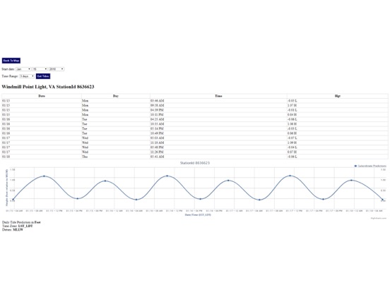
Ability to forecast Washington tides from NOAA by setting date and period for any of the tidal stations for the entire State of Washington tide tables.
Excellent support for any issues, questions or new features...simply email: [email protected] and we'll show you how Apple support is meant to be.
When GPS is available auto-locate your position and zoom to the map for surrounding NOAA Washington tide charts.
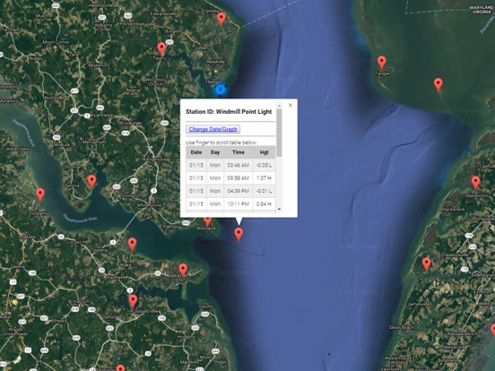
Included is the ability to zoom and view satellite imagery for fishing ground characteristics to compare with tide movement.
Advanced tide graphs allow for you to judge the level of water movement for optimal fishing between high and low tide in Washington between tide stations so you can follow the tide flow for the entire day.
Recent Feedback:
"NesTides ability to display tide predictions and actual tidal flow graphs allow me to extend fishing trips by following different tide station tide charts and moving with the tide flow. The satellite view allows me to explore and discover new fishing grounds I never knew existed. Absolutely the best fishing software tool I have ever used. ," said USCG Captain Mike K.
Partial list of NOAA Washington Tide Stations, see website for full list:
Columbia River entrance (N. Jetty),CAPE DISAPPOINTMENT,Fort Canby, Jetty 'A', Wash.,Ilwaco, Baker Bay, Wash.,Chinook, Baker Bay, Wash.,Hungry Harbor, Wash.,Hammond, Oregon,Point Adams, Oreg.,Astoria (Youngs Bay), Oreg.,Cathcart Landing, Youngs River,Warrenton, Skipanon River, Oreg.,Astoria (Port Docks), Oreg.,ASTORIA (Tongue Point), Oreg.,Knappa, Knappa Slough,Settlers Point, Oreg.,Harrington Point, Wash.,Skamokawa,Wauna,Cape Horn,Barlow Point,Longview,Temco Kalama Terminal,Saint Helens,Knapp Landing, Willow Bar,Rocky Point,Portland Morrison Street Bridge,Vancouver,Washougal,Beacon Rock State Park,Nahcotta,Tarlatt Slough,Greenhead Slough,Paradise Point, Long Island,,PORT TOWNSEND,Marrowstone Point,Mystery Bay, Marrowstone Island,Bush Point, Whidbey Island,Port Ludlow,Foulweather Bluff,Port Gamble,Lofall,Bangor Wharf,Zelatched Point, Dabob Bay,Whitney Point, Dabob Bay,Quilcene, Quilcene Bay, Dabob Bay,Seabeck, Seabeck Bay,Pleasant Harbor,Triton Head,Ayock Point,Union,Lynch Cove Dock,Hansville,Edmonds,Kingston, Appletree Cove,Port Jefferson,, Case Inlet,Allyn, Case Inlet,Walkers Landing, Pickering Passage,Shelton, Oakland Bay,Arcadia, Totten Inlet,Barron Point, Little Snookum Inlet Entrance,Burns Point, Totten Inlet,Rocky Point, Eld Inlet,Dofflemeyer Point, Boston Hbr., Budd Inlet,Budd Inlet, Olympia Shoal,Olympia, Budd Inlet,Glendale, Whidbey Island,Everett,Marysville, Quilceda Creek,Priest Point,Tulalip,Spee-Bi-Dah,Tulare Beach, Port Susan,Kayak Point,Stanwood, Stillaguamish River,Sandy Point, Whidbey Island,Holly Farms Harbor, Holmes Harbor, Whidbey I.,Greenbank, Whidbey Island,Crescent Harbor, N. Whidbey Island,Coupeville, Penn Cove, Whidbey Island,La Conner, Swinomish Channel,Sneeoosh Point,., Padilla Bay,Armitage Island, Thatcher Pass,Strawberry Bay, Cypress Island,Peavine Pass,Tide Point, Cypress Island,Gooseberry Point,Point Migley,Chuckanut Bay,Bellingham,Village Point, Lummi Island,Sandy Point, Lummi Bay,Rosario, East Sound, Orcas Island,Upright Head, Lopez Island,Orcas, Orcas Island,Richardson, Lopez Island,Shaw Island, Ferry Terminal, Harney Channel,Friday Harbor, San Juan Island,Echo Bay, Sucia Islands,Ferndale,CHERRY POINT,Blaine, Semiahmoo Bay,POINT ROBERTS, PUGET SOUND,Kanaka Bay, San Juan Island,Hanbury Point, Mosquito Pass, San Juan I.,Roche Harbor, San Juan Island,WALDRON ISLAND, PUGET SOUND,Patos Island Wharf
tide chart,tide tables,tides,tide tables puget sound,saltwater tides,seattle tide table,puget sound tide chart,tide schedule,tides near me,tides for fishing